Karst
When I was a teenager, I helped to create the Netherlands Speleological Society. We used to go to the Belgian Ardennes for caving, and there were often discussions about the origin of caves and the geomorphological aspects of karst. I studied Physical Geography at the Universiteit van Amsterdam in the Netherlands and my friends expected me to have answers to some of these questions.
I enquired where I could learn more about karst, and discovered that Dr Pete Smart in the Geography Department of the University of Bristol in the UK was looking or a research assistant. In 1977, I moved to Bristol, and I became a member of the University of Bristol Speleological Association (UBSS). I started my karst studies and obtained my PhD in 1982, based on research of water in the unsaturated zone of a limestone aquifer.
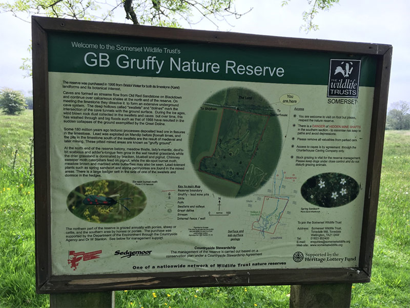
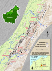
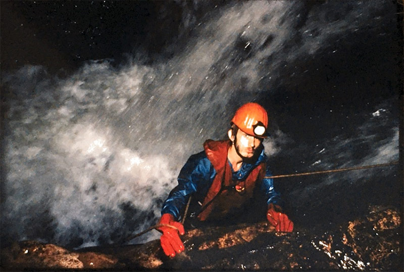
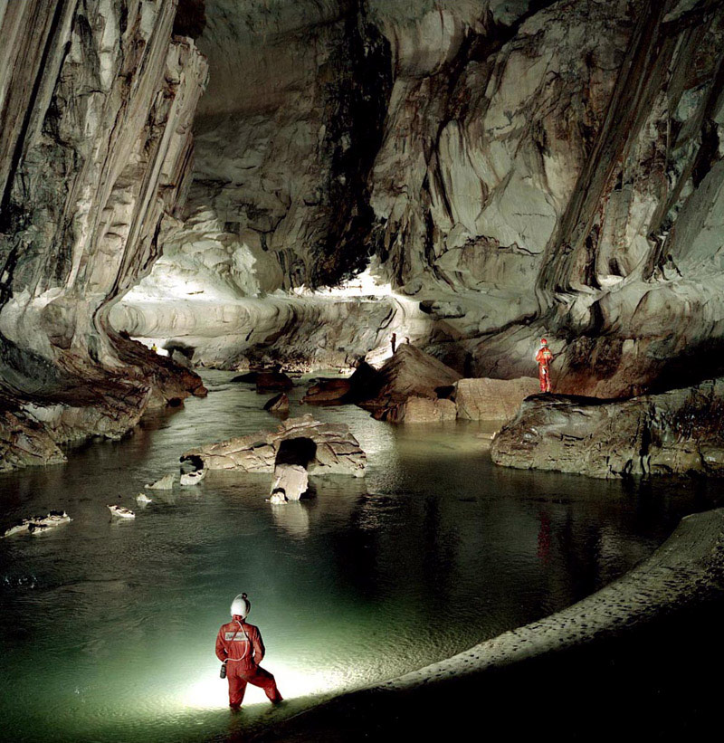
The main research location was GB Cave in the Mendip Hills in Somerset, but I also visited several other karst areas in the UK and Ireland, and I joined a caving expedition to the Picos d’Europa in northern Spain. My research in the Mendip Hills was a combination of surface and soil moisture measurements, together with analysis of water quantity and quality, both in the soil and in the cave. It included measuring the flow of water inlets in GB cave with specially designed equipment, and collecting water samples from several specific locations in the cave two times per week. I spent many hours underground, typically during solo trips.
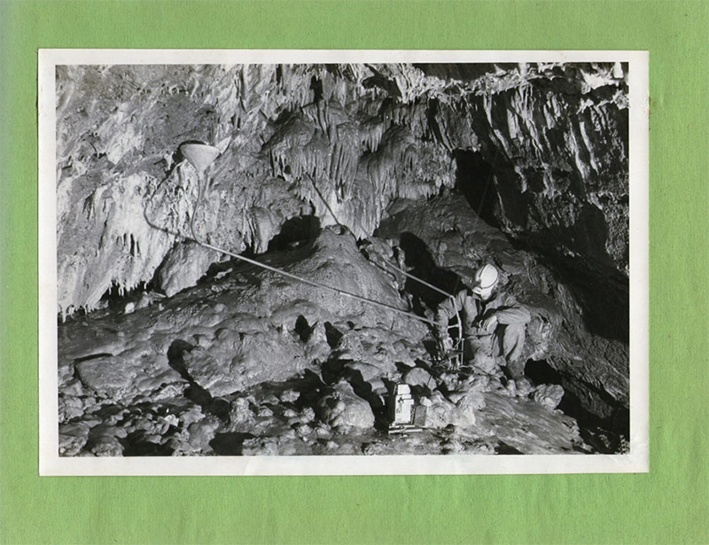
The samples were analysed for a range of elements in the Geography Department laboratory during the evening of the day of collection, and the results provided a wealth of information. The most interesting findings of my research related to the unexpected high storage of water in the upper levels of the limestone, and the surprisingly differentiated flow patterns of underground water during periods of heavy rain.
In 1978, I had the privilege to join the Royal Geographical Society expedition to the karst area near Mulu mountain in northern Sarawak, Malaysia. The main aim of the expedition was to prepare a management plan for what is now the Gunung Mulu National Park, and I joined the expedition to carry out morphological and hydrological research. As a member of the expedition, I was approved as a Fellow of the Society, and since that time I can call myself FRGS.
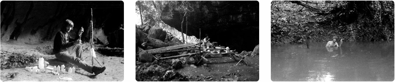
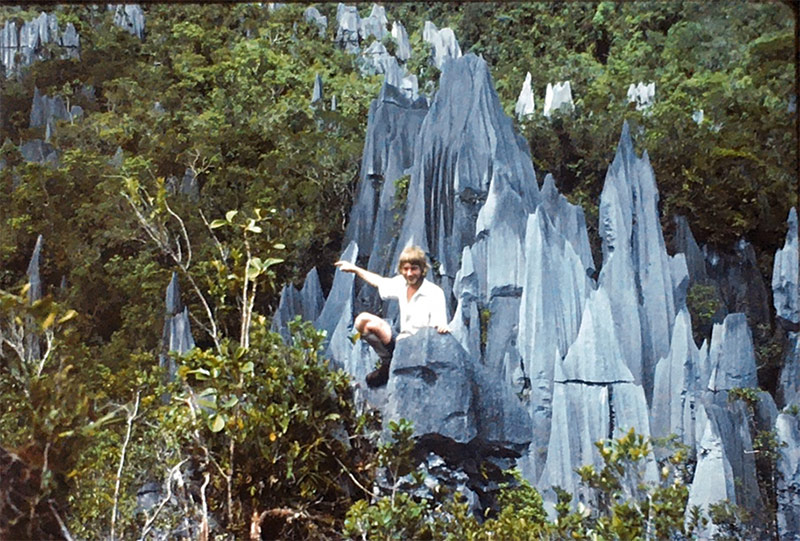
 The management plan of the Gunung Mulu National Park highlighted the immense potential of the underground karst, with the discovery of some of the largest cave systems in the world. I was therefore extremely happy to join a follow-up expedition during the end of 1980 and the beginning of 1981. This expedition was purely a caving trip, with the aim to explore and map the caves of the area, and the start of the Mulu Caves Project that is still going on (www.mulucaves.org).
One of the specific questions I was asked to answer was the direction of the water that disappeared in the floor of the so-called Hidden Valley, as we expected this to flow underground into the main river passage of Clearwater Cave. My water tracing studies suggested another connection, and after further review of the aerial photos of the area, I identified a possible location for a potential spring. A field visit confirmed the existence of a flowing river in a large canyon, but the size of the passage and the water flow forced me to abandon a visit into the cave. I returned, together with the expedition leader Andy Eavis, and the exploration of the passage led to the discovery of a large underground space.
A video by Sid Perou has recorded this first visit.
As the water in the cave was rising, after heavy storms outside, we left the cave and eft further exploration to colleagues on the team. Their subsequent visit and the measurements of the space, resulted in the definition of the largest underground cave in the world: Sarawak Chamber.
The caves of Gunung Mulu have become a real tourist attraction. This website provides more information from a visitor’s perspective: https://www.thecultureist.com/2015/09/09/exploring-the-caves-of-borneos-gunung-mulu-national-park/
At the completion of my PhD research in Bristol, I landed the only job dealing with caves that I have ever had. I joined three other karst and cave specialists in mid-1982 to help an engineering company in central Java that was looking for water in the Gunung Sewu karst area. We explored caves to find potential sources of water for local communities, as the area had no piped water system in those days. The satisfaction was to find some underground lakes and underground rivers that could provide irrigation and drinking water.
Gunung Sewu is now a UNESCO Global Geopark (View Video)
My next karst exploration opportunity was a visit to Guizhou Province in southern China, as a member of the 1984 China Caves Project. We spent time looking for caves that could be developed for tourism, and we looked for information about underground flow. The China Caves Project has returned for further research, but I was not part of that.
I had a few activities related to karst later on in my life, when I worked for IUCN in Asia, but my future career went into other areas, and 1984 China Caves trip was the end of my active caving life and my karst research activities.
Wetlands
My interest in wetlands started early on. In fact, one of my first experiences is rowing a small boat through the “Biesbosch” coastal wetlands in the Netherlands, during the days that I was a member of the Dutch youth nature group (Nederlandse Jeugdbond voor Natuurstudie – NJN). We visited the wetlands to see migrating birds and generally experience the environment. The Biesbosch is now a National Park, and moving around with a canoe or rowing boat is one of the recommended ways of seeing the area. https://np-debiesbosch.nl/english-information.
My karst explorations are part of my interest in wetlands as well. After all, karst springs and subterranean rivers are considered wetlands by the Ramsar Convention on Wetlands. (https://www.ramsar.org/document/resolution-vi5-inclusion-of-subterranean-karst-wetlands-as-a-wetland-type-under-the-ramsar). Exploration of underground streams, and locating springs in remote areas was one of the exciting aspects of my caving days.
After I joined IUCN in Nairobi in 1989, I was overseeing several projects in the East African Region, one if which was the development on the Uganda National Wetlands Programme. Uganda has many lakes, including a part of Lake Victoria, and arguably the start of the White Nile. The Ministry of Water and Environment claims that wetlands cover an area of 11 per cent of the country. The project manager of the Uganda Wetlands Programme was Paul Mafabi, who eventually became the Director for Environment. We were in touch regularly during the past decades, and Paul sadly died from a COVID-related illness in 2020.
In 1995, Uganda made history as the second country worldwide, after Canada, to pass a wetlands policy, which was the main achievement of the IUCN-supported project. The National Policy for the Conservation and Management of Wetlands is based on five objectives which revolve around the principles of sustainability, improving wetlands productivity and diversity and good governance.
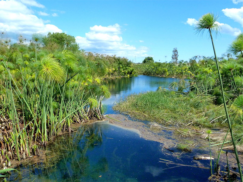
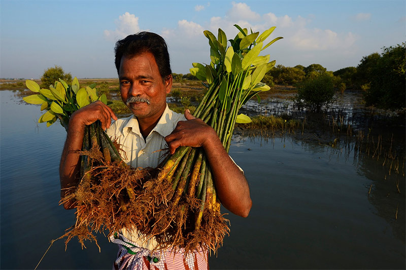
Most of the wetlands in Uganda have papyrus as the main vegetation, and we looked at many ways in which this could be used to provide socio-economic benefits. My colleague Lucy Emerton worked out the value of papyrus wetlands for water filtration, and another economic opportunity was to make briquettes from papyrus. This is still an unexplored area of rural development, and I wonder why.
I moved to Vietnam in 1994, and was involved in the preparation of the Biodiversity Action Plan, but in those days, Vietnam had no national wetlands policy, although UNDP claims that an estimated 30% of Viet Nam comprises inland and coastal wetlands.
A comprehensive assessment of wetlands status in Viet Nam, titled “Overview of Wetlands Status in Viet Nam Following 15 Years of Ramsar Convention Implementation” was published in 2006. But only recently, in 2021, a national 10-year action plan on the conservation and sustainable use of wetlands was launched.
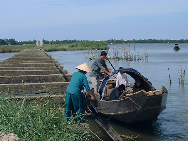
The coastal wetlands and the river deltas of the Red River and the Mekong River are spectacular, and Thua Thien Hue Province has a magnificent lagoon that is a key source of fisheries and aquaculture. I spent many days in the area, as we had extremely good relations with the provincial environmental bureau. One of the main efforts involved a proposal for integrated water resources development of the lagoon and its feeders, and I believe some of the proposed activities were subsequently implemented.
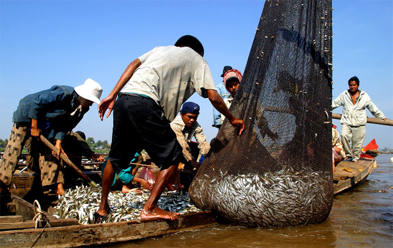
When I moved from Hanoi to Bangkok in late 1999, I was appointed as the Asia Regional Head of the IUCN Water and Nature Initiative (WANI) and I was the team leader of the UNDP/GEF Mekong Wetlands Programme. Under this programme, we developed a regional strategy for wetlands conservation in the lower Mekong and implemented field projects in northern Thailand, southern Laos, Cambodia and the Mekong Delta in Vietnam. Keys issues, then and now, were the effect of dams on the flow of the Mekong River, and the impact this has on the annual flooding of Tonle Sap lake in Cambodia. Tonle Sap provides astounding volumes of fish during the high water season, which feeds a large population and provides significant amounts of hard currency for the Cambodia treasury. Estimates from the WorldFish Centre range from 150 to 250 million USD per year.
As regional WANI Coordinator, I took charge of some of the regional consultation meetings about the findings of the World Commission on Dams, and I wrote project proposals for water-related activities in southern China, India and Nepal. I was also the Asia liaison officer for IUCN with the Ramsar Convention Wetlands.
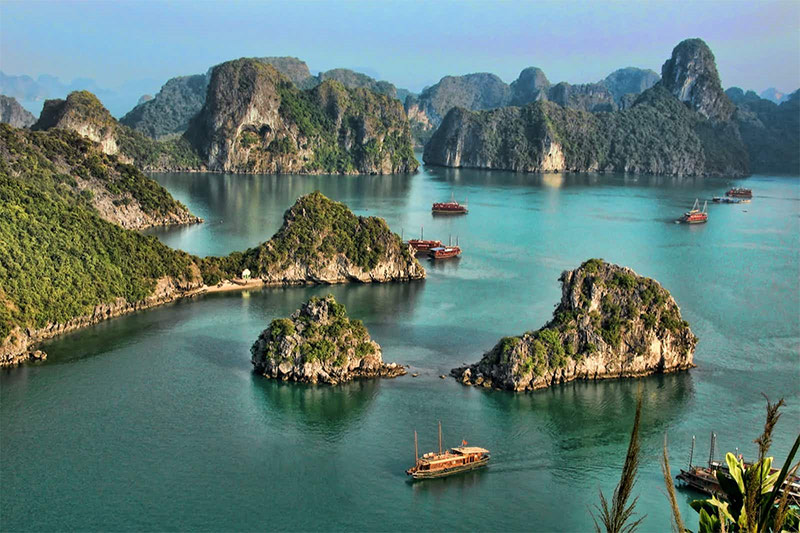
During my time in Southeast Asia, I was part of World Heritage assessments of Puerto-Princesa Subterranean River National Park in the Philippines and Phong Nha Ke Bang karst landscape in Vietnam, and I helped to expand the criteria for Halong Bay World Heritage Area in Vietnam.
In 2004, I moved to IUCN Headquarters, and took charge of global partnerships and fundraising, and one of my achievements was the seed funding for the Mangrove for the Futures initiative. http://www.mangrovesforthefuture.org/. The first 15 million USD seed funding was secured during a donors meeting in New York on Tuesday 31 October 2006 at the office of former US President Bill Clinton in his capacity as UN Special Envoy for Tsunami Recovery.
The initiative was developed as a response to the devastating tsunami in 2004, and the programme was launched in December 2006 in Hin Look Dieu village, Phuket, Thailand by President Clinton as a strategic and long term response to the continued degradation of coastal ecosystems threatening the livelihoods and security of coastal communities throughout the Indian Ocean Region.
When I became Regional Director for Europe, I was responsible for the Membership links with organisations like Wetlands International who have their Headquarters in the Netherlands, and Birdlife International who are based in UK. We also were involved with Protected Area management efforts in Europe, which included the delta of the Danube River, the Camargue and a number of other key wetlands in Europe.
I have always taken great interest in the Ramsar Convention on Wetlands, and applied to become the Secretary-General in 2013. Unfortunately, I was not successful and I moved instead to China as the Director-General of the International Bamboo and Rattan Organisation. This is described elsewhere.